GeolOil copyrighted Logo
Home link icon CD Product Icon Products Services Icon Analyses Learn Icon Learn Set Download Icon Downloads PriceTag Icon Prices Team Icon About Contact Icon Contact Youtube video 20 px icon Videos

4.5 ★★★★☆
(13 Google reviews)


Products Icon PRODUCTS


Services Icon ANALYSES


HandBook Icon RECIPES


Paper Icon PAPERS


Reference Flag Icon REFERENCE


Map digitizer


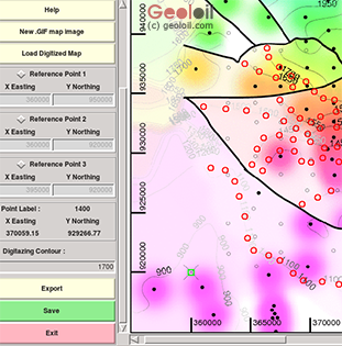
Our GeolOil map digitizer allows to quick and easy digitize maps. How many times have you had only a paper legacy map, or a reference .PPT or .PDF presentation from which you need to digitally capture that information?


You can retrieve all the coordinates information displayed in the map, like fault polygons, cultural polygon and lease outlines, well coordinates, contouring values and its coordinates, getting their (x,z,value), etc. Then export the digitized data to a plain ASCII file readable and editable by virtually any software.


Digitizing a map with GeolOil

Just only defining three reference points, either on a framed coordinate system or by clicking on three wells with known surface coordinates, you can start to digitize the map. Capture mapping contourings, fault polygons, field boundaries and any information you want to convert to (x,y) coordinates ASCII data.


Content, and web design © 2012-2022 GeolOil LLC. You are welcome to refer them. Please give us fair credits under Creative Commons License CC-by-ND